Field Work, May 16-June 3, 2022
Between May 16 and June 3, 2022 students from the University of Central Arkansas (UCA) and the University of Arkansas at Little Rock will participate in the fourth year of archaeological research at Camp Halsey (3FA313). These efforts are part of the Field Archaeology course offered at UCA during the May Intersession, along with an internship offered by the Jamie C. Brandon Center for Archaeological Research (JCB Center). Fieldwork at Camp Halsey is part of a long-term collaborative project between UCA, the JCB Center, and the Faulkner County Museum to map, evaluate, and document historical and archaeological resources throughout Faulkner County. This project is organized into three themes that serve to frame inquiries and engage student participation: site administration and management, pedagogy and public archaeology, and research.
The 2022 fieldwork will build upon previous seasons using a multi-disciplinary systematic approach to address specific research questions related to social, historical, economic, and political aspects of the camp. Students will learn to apply several archaeological field methods during their time in the field. Broadly, they will be collecting five types of data: resistivity and metal detecting (terrestrial geophysics), drone (aerial photography), total station (mapping and topography), and excavation (archaeological).
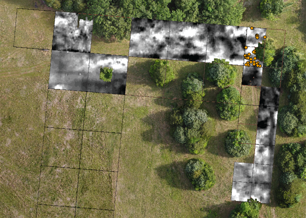
Students will have an opportunity to use electrical resistivity to continue mapping the site and identify distribution of buried features (anomalies). In 2019 and 2021, the collection of resistivity data proved to be productive when compared to the location of buildings visible in historic aerial images and consideration of subsurface preservation of features. Added to this dataset has been the mapping of artifact-type distribution collected using systematic metal detecting survey. Students will use an RM Frobisher TAR-3 resistivity meter and learn skills related to site survey and systematic field data collection, applied physics, resistance, and processes of landscape use and modification.
Students will also be exposed to the application of drone technology in archaeology in order to conduct low-altitude aerial photography of the landscape and identify visible site features, as well as document environmental changes of the site over time. First collected during the 2021 season, comprehensive aerial imagery has been useful in identifying variation in surface vegetation that corresponds to buried subsurface archaeological deposits. In addition, drone imagery has assisted in the creation of a site mosaic from multiple elevations that can be used to integrate with other forms of distributional data, such as results from resistivity and metal detecting surveys.
New to the 2022 season is the use of the recently purchased Topcon GM-55 total station. The addition of a total station to the JCB Center will allow students to gain knowledge in mapping site features that can be applied and utilized in many spatial disciplines and job requirements. Students will also continue, along with the collection of drone imagery, the generation of an elevation map of the site that will expand upon earlier collected data from instruments borrowed from the Arkansas Archeological Survey during the 2019 season.
Students will gain experience in traditional excavation methods and learn skills related to developing and refining research questions as data are collected, the importance of clear and concise field note taking, the process of creating profile and plan sketches, and learn how field artifacts are assigned provenience and collected (tagged and bagged) in the field (in accordance with Arkansas Archeological Survey statewide standards).
Plans are underway to investigate three archaeological features. The first is Feature 11, the location of the officer’s quarters. During previous seasons, students documented the base of a former chimney and the location of a cement slab that served as the front screened porch. Additional units will be opened in this area with the anticipation of defining the size and extent of the structure. The second is Feature 15, located north of Feature 10 (Auto Garage, excavated in 2018, 2019). Feature 15 is currently hidden in vegetation overgrowth and is thought to represent the remains of a second well that was dug in 1935 and located “50’ South of Barrack No. 12” (as noted in the 1934 inventory of buildings). If time permits, students will also document the location of the Water Tank Tower (Camp Building #21; Feature 6) located on the western edge of the camp. At the tower location, four steel pillars remain that will shed light on the type of construction utilized and the relationship of the water tower to the overall camp organization.
During the third week, students will gain experience in archaeological lab methods and learn skills related to artifact cleaning, cataloging, and accessioning. They will be exposed to the process of conducting a preliminary analysis using a handful of artifacts, methods associated with digitizing field sketches, remote sensing data processing, and the use of primary historical documents to supplement artifact data.